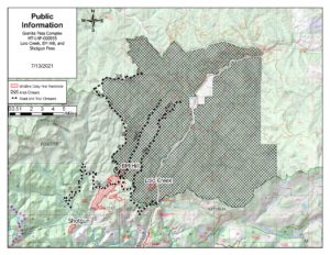
STATISTICS• Location: Near Lolo Pass • Date of Origin: Early July 2021 • Cause: Lightning • Total fire acres: 1,139 acres • Containment: 0% • Cost: not yet available • Structures Threatened: 1 residence, and 1 minor structure. Lolo Hot Springs and Granite Hot Springs are not immediately threatened but could become threatened if conditions change. |
RESOURCES• Crews: 1 Hotshot Crew, District Modules • Engines: 1 • Helicopters: Air Attack, Helicopter shared between other fires in the area • Water Tenders: 0 • Dozers/Excavator: 2 • Personnel: 52 |
||||
SUMMARY
This complex is comprised of three fires burning on two National Forests near Lolo Pass. The Lolo Creek Fire is burning on the Missoula Ranger District in Montana and the BM Hill and Shotgun Fires are on the Powell Ranger District in Idaho. All fires in the Granite Pass Complex are being managed under a full suppression strategy.
Public and firefighter safety is the number one priority. Additional priorities include minimizing impacts to private property and structures, and highway corridors. Due to high fire activity in our region and across the country, resources are limited and are prioritized where need is aligned with values at risk, such as infrastructure and private property.
COMPLEX UPDATES
Managers are in the process of placing a larger area closure of Lolo National Forest lands in effect today. All forest lands south and southwest of the Howard Creek Road Junction with Highway 12 to the Lolo Pass Visitor Center will be closed including East Fork Lolo Creek Road #461, Lee Creek Road #699, and the southern portion of the Fish Creek Road #343 starting at mile marker 23.8 (Oriole Junction) to Highway 12. Access to Fish Creek is still open from I-90 to mile Marker 23. A detailed closure map and order will be forthcoming.
Objectives include point/zone protection, structure protection, protection of public and highway commerce emphasizing suppression and holding the fire to the west of Highway12 where it is safe to do so. Yesterday, a hotshot crew and air resources were diverted to provide initial attack on a new fire start within the Lee Creek drainage.
FIRE WEATHER
Continued hot and dry conditions are expected today.
FIRE UPDATES
BM HILL FIRE
Location: Ten miles north of Powell Junction, and is burning on both the Nez Perce-Clearwater and Lolo National Forests
Acres: Approximately 988
Discussion: The BM Hill Fire is now burning on the Missoula Ranger District/Lolo National Forest in Montana northwest of Highway 12. Fire behavior continues to be active with short crown runs and some group torching. It is expected to merge with Lolo Creek Fire in the coming days.
LOLO CREEK FIRE
Location: 1.5 miles northwest from the Lolo Pass Visitor Center and is burning on the Lolo National Forest.
Acres: 79
Discussion: The Lolo Creek Fire continues to burn actively and is expected to merge with the BM Hill Fire in the coming days. Yesterday, crews set up hose and sprinklers to protect structures at Lolo Hot Springs.
SHOTGUN FIRE
Location: Seven miles north of Powell Junction on both the Nez Perce-Clearwater National Forests.
Acres: 72
Discussion: The Shotgun fire is burning in heavy dead and downed timber in steep terrain. Firefighters are assessing suppression options for this fire.
EVACUATION INFORMATION
The Missoula County Sheriff’s Office issued an Evacuation WARNING from the Idaho border to Lolo Hot Springs. Deputies will be notifying residents and visitors along Highway 12 of the Warning. Residents and visitors in the area should stay vigilant of the current situation and be ready to immediately leave the area if an evacuation ORDER is issued. If you are traveling along Highway 12 please do not stop. For more information visit https://www.facebook.com/MissoulaCountySheriffsOffice.
CLOSURE INFORMATION:
For closure information visit Inciweb: https://inciweb.nwcg.gov/incident/7653/.
