By Michael Howell

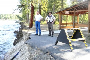
Prolonged high water flows on the Bitterroot River this spring cut into the bank along the Lee Metcalf National Wildlife Refuge undermining the asphalt trail that was paved to allow for ease of public access as well as handicapped accessibility to the river. The collapsing bank now threatens to take out the nearby Education Shelter built as a memorial to a young Stevensville boy who died when hit by an automobile while riding his bicycle to the river. Another paved trail located along the roadside from Stevensville to the river access site at the Stevensville Bridge was constructed in response to the tragic accident.
Outdoor Recreation Planner Bob Danley said that over 20 feet of the asphalt trail collapsed into the river over the span of about two weeks. He said that prolonged high water flows cut into the bank undermining the sidewalk but that the strong flows must have also served to hold the bank in place. It was only after the water levels dropped that the paved trail began to quickly collapse.
Refuge Manager Tom Reed said that discussions were already underway with the family about possibly moving the Education Shelter that was built as a memorial to young William Wyatt.
“We don’t want to lose it,” said Reed. “This was built as a memorial and these things are very important.” He said the spot was chosen as a place where people could relax by the river and enjoy its calming and refreshing nature. The plan is to keep it in the area but move it a good distance back from the spot where the river is cutting through.
In fact, the current plan, which is still taking shape, involves removing the asphalt trail completely and re-establishing it with a trail that would run atop a nearby levee further to the east that was probably an old road bed. This would give the river room to shift eastward as it makes its own way across the floodplain in that area.
The washed out trail is a designated part of the Nez Perce, Lewis and Clark and Ice Age trail systems, but, according to Danley, it does not mean that Lewis and Clark actually walked along that very spot.
“This is an area that the Corps of Discovery and the Nez Perce passed through. We don’t know where they stepped exactly,” said Danley. This historic designation could help in getting the funding needed to make the required fix. The money would come from federal transportation funds although it is not a part of the road system.
Reed speculated that the riprap and bank armoring that took place upstream, aimed at protecting Stevi River Road, is contributing to the river’s movement to the east as it bounces off the armored bank. He said that the permitting system that allows for bank stabilization along the river does not adequately address cumulative impacts as the river’s energy is re-directed and transferred downstream. He said the problem is simply pushed downstream to the next property owner.
De-construction and removal of the remaining portions of the sidewalk and recovery of the large chunks that are now in the river is a perplexing issue, according to Reed.
“It’s complicated. It’s not simple. There are a lot of conflicting concerns,” said Reed. “We will have to be creative and do the best we can.” He said while some advocates for the river, like the Bitterroot River Protection Association, want something done quickly about the asphalt that has already fallen in the water, there is no easy and clear way to do that. It will take some heavy machinery to handle the large portions of asphalt strewn along the river bank and on the river bed. But the bank is high, steep and completely unstable at this point in time, making use of heavy equipment problematic.
Although the Bitterroot River Protection Association offered to put together a band of volunteers to help in the process, the large size of many of the asphalt chunks and the need for machinery make it complicated to use untrained volunteers on the project.
Reed is researching and consulting with experts in an effort to determine the nature of the threat to the water quality of the river. He said initial research and consultation indicate that toxicity is not a problem. He said asphalt itself is a naturally occurring substance and that most mixes only contain about 10% asphalt. The rest is rock and gravel. He said asphalt is actually used in lining the beds of drinking water reservoirs.
The sealant often applied to asphalt is another story, especially cold-tar sealant. Asphalt on roadways that has accumulated oil, antifreeze and other potentially toxic materials from automobiles is also a source of pollution. He said the fact that this asphalt only received foot traffic and did not get the kind of repetitive sealant application that roadways require was a good thing. He said there was no indication of any fish kill or any oil slick in the area.
Reed said that at this point he did not really know the effects of submerged asphalt on water quality.
“But first and foremost is the safety issue,” said Reed. “If we deal with this we’ve got to do it safely.” He said rushing in without a well thought out plan and plenty of precaution could turn out to be counterproductive.
Allowing the river to move naturally across the floodplain in the Refuge is part of the long term management plan that was recently adopted. That’s one reason they are looking at moving the trail system rather than armoring the bank, although the placement of some sort of softer, bio-engineered bank protection in the area is also being considered.
“The river is our most valuable resource,” said Reed, “and the bottom line is we are looking to re-locate the trail.”