The U.S. Fish and Wildlife Service is approaching the end of its second season of monitoring in the Bitterroot for the presence of Grizzly bears. Project leader Jennifer Fortin-Noreus gave the public an update on the project results recently in Hamilton. The project, which is a partnership between the U.S. Fish and Wildlife Service, the Bitterroot National Forest and Defenders of Wildlife, consists in constructing bait stations in the woods surrounded by barbed wire and cameras to capture photographs and hair samples for DNA identification.

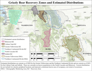
Based on historical evidence, three separate areas in Montana have been identified as harboring known populations of Grizzly bears, one in the northwest corner of the state, another in the south/central part of the state and one stretching from the Canadian Border extending through the Cabinet Mountains as far east as Great Falls and Helena and south of Missoula
In 1993, eight different areas were identified as good grizzly bear habitat and were adopted as official Grizzly Bear Recovery Zones. The Bitterroot RZ is mostly located in Idaho but does extend across the border into the Bitterroot National Forest on the west side of the valley.
According to Fortin-Noreus, the bears are known to wander outside the areas where continual occupation has been verified. The areas where bears have been sighted outside the currently recognized occupied areas, called Species List Areas, have also been mapped and designated as areas where grizzly bears “may be present.”
Species List Areas (or “may be present” map) help federal agencies determine where effects to listed species should be considered for consultation from actions they carry out, fund, or permit to meet requirements under Section 7(a) of the Endangered Species Act (ESA). As grizzly
bears expand their range, the SLA is intended to be spatially inclusive of all areas that meet the “may be present” methodology for grizzly bears. The “may be present” methodology is derived from current distributions and verified location data outside of current distributions; not all areas that are designated as “may be present” meet the criteria to be included in current distributions.
Local evaluation is needed by federal Level 1 ESA Streamlining Teams to determine potential effects of agency actions where grizzly bears “may be present.” Identifying locations where grizzly bears “may be present” will facilitate project planning activities that promote grizzly bear conservation and recovery. The grizzly bear SLA is updated with any new verified sightings every 90 days. Last updated July 26, 2022 with data from 2012 to July 26, 2022.

Fortin-Noreus said that the aim of the current study was to get more information on the number of bears that may be using the Species List Area and determine the sex.
“We don’t know if these are resident bears or bears just passing through,” said Fortin-Noreus. “We don’t know if they are male or female and we don’t know if they are having cubs. So, the goal is to get more information about these bears in the intervening areas.”
Last year, the first year of the study, there was only one detection, involving two bears at the same site. One of the bears was captured as a conflict bear in the Flint Creek drainage in 2020 and moved north of Interstate 90. But it was sighted in 2021 along with another grizzly at one of the corral sites. Both were males from the Northern Rockies Ecosystem, but completely unrelated to each other, according to the DNA analysis.
This year the project has a better chance of success, thanks to a contribution from Defenders of Wildlife. The first year there was only one full-time crew working on the project, but this year Defenders of Wildlife is paying for a second full-time crew. 124 sites were established, mostly on the Sapphire Mountain side of the valley. The sites are visited every month from May through August. So far this year, no Grizzlies have been identified. The two Grizzly bears that were sighted in the Bitterroot River bottom this summer were captured and relocated to the Welcome Creek Wilderness in the Sapphire range but have since left the area and wandered north of Interstate 90.
Fortin-Noreus said that the public can help in the efforts to track these Grizzlies by documenting sightings of a bear with a photograph or a photograph of a bear track. She cautioned that both black bears and Grizzly bears come in different colors, making color a poor criteria for identification. Although a person may see a bear and believe it was a grizzly, no sightings are considered “verified” unless made by a trained bear specialist or based on evidence such as a photograph of the bear or a bear track, or some hair that can be analyzed for DNA identification.
As a side note, Fortin-Noreus said that some “rub trees” have been found where bears naturally scratch themselves on tree trunks and may leave hair samples. She said these trees are being documented and included in the sampling sites for future hair collection.