by John Dowd
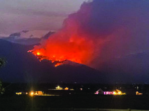
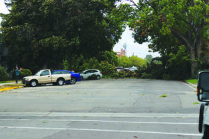
Last Friday, August 23, the Bitterroot Valley saw massive wind storms and lightning strikes throughout the valley, from Hamilton to Stevensville. Throughout the valley, heavy wind gusts toppled trees and caused several major power outages. Lightning strikes caused a fire on St. Mary’s Peak in the Sharrott Creek area about four miles west of Stevensville on the Bitterroot National Forest which has already grown to over a thousand acres and resulted in some evacuations.
According to the Bitterroot National Forest, the Sharrott Creek Fire started about 3:45 p.m. on Friday, during the extreme wind event. The wind caused “running, torching and long-range spotting uphill and to the north.” On Monday morning, the Forest reported on its Facebook page tha “temperatures dipped down to 45 degrees near the fire last night which caused RH [relative humidity] levels to go up. The cool moist air has settled in the valley; however, the fire is currently located on the mid slope where the air is a little warmer and drier which continues to support fire activity with some visible torching this morning. With the lack of strong winds today the smoke will linger.”

As of Monday, the fire was estimated to be 1,048 acres in size. Aircraft and helicopters have been attacking the fire with retardant and water drops. Engine and ground crews were working on contingency lines, with a total of 258 personnel assigned to the fire. On Monday, firefighters planned to start proactively burning out small portions of the east edge of the fire, spanning about a mile and a half, hoping to provide an effective anchor point to start securing the fire edge. Burnouts are done to remove unburned fuel between containment lines and the fire’s edge. This strategy allows for better control of fire intensity. If a fire reaches the line with too much intensity, a line may not be able to hold the fire, according to Bitterroot Forest information.
A Type 1 Incident Management Team under the direction of Mike Behrens was expected to take over management of the fire on Tuesday morning. The fire incident command camp is located at the Fort Owen Ranch. An information trailer is located in the Super 1 parking lot.

According to the Ravalli County Sheriff’s Office, as of Monday, evacuation orders remained in effect for the areas west of the intersection of Kootenai Creek Road and Timber Trail, to include residences on Timber Trail; west of the west side of Sharrott Hill Loop, to include residences on Blue Grouse Lane, Redtail Hawk Lane and Porcupine Lane, Marmot Lane and Saint Marys Lookout Road, west of Saint Marys Road.
Evacuation warnings remain in effect for the area of North Kootenai Creek Road west of Wakantanka Way; west of the east side of Sharrott Hill Loop; west of Salish Trail; west of the intersection of Saint Marys Road and Salish Trail; and west of Saint Marys Road and the intersection of Indian Prairie Loop.
An evacuation shelter is available at the LDS Church in Stevensville at the corner of Middle Burnt Fork Road and Eastside Hwy. Evacuation questions can be directed to the Ravalli County Emergency Operations Center at 406-375-6650. The Sheriff’s Office asks that people not call 9-1-1 for questions regarding fire or evacuation information.
Ravalli County Sheriff Steve Holton said that on Monday morning residents over 18 years old from evacuated areas were being given access through the roadblocks to check their homes and properties. Sheriff Holton also issued a statement thanking the residents and Stevensville community for their patience and understanding over the last three days. “While evacuations and roadblocks are certainly inconvenient, we are thankful that no one has been injured and no private property has been affected,” said the statement. “The Sheriff’s Office is constantly assessing the need for evacuations and will rescind the orders as soon as it is safe to do so.”
A community meeting is scheduled for Tuesday, August 27 at 7 p.m. at the Stevensville High School gymnasium.