by John Dowd
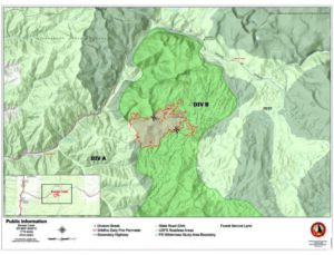
Several forest fires in the area surround the Bitterroot Valley. The largest and most urgent of these is the Bowles Creek Fire, just three miles west of Skalkaho Pass. A lightning-caused fire, the blaze is quickly growing in size, going from 1,555 acres reported on July 25, to over 1,700 by July 31. Fire crews mapped the fire with an overnight flight on July 25, which showed the extent of the burn. According to the Northern Rockies Incident Management Team working on the fire, the windy conditions over the weekend, along with drying fuel, are not helping the situation with any of the fires.
The Bitterroot National Forest and Beaverhead National Forest are both in very high fire danger status. Though Skalkaho Pass remains open, numerous roads through the area have been closed. Travelers moving through the pass are encouraged to slow down and be aware of increased traffic from fire crews. The fire had reached only 3% containment by July 31. Smoke has been moving in from various fires in the region. For more information visit www.airnow.gov or www.montanawildfiresmoke.org.
Another fire in the north portion of the Bitterroot Valley had several evacuation notices in effect on Sunday evening. A fast moving fire was burning in areas north of Mormon Creek Road to Highway 12, near Traveler’s Rest State Park west of Lolo. Though the evacuation notice for the area had been lifted as of Monday, several roads were still closed, including Jade Lane, west of Agate Drive.
According to Montana Public Radio, “people who have evacuated can find assistance and more information at the Cold Springs Elementary School at 2625 Briggs St, in Missoula. People needing assistance due to this fire may also call the Red Cross at (406) 215-1514,” regarding any evacuation notices for this area.
Further west, along Highway 12, is the Little Bear Fire, which is nearly 800 acres in size, and as of Monday was 15% contained. Fortunately, since July 30, minimal growth has been reported.