By Michael Howell
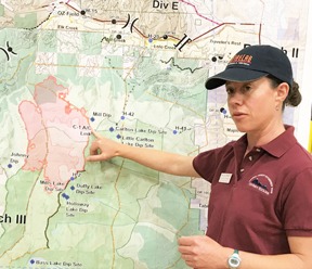
According to LaWen Hollingsworth, Long Term Fire Analyst from the Missoula Fire Research Laboratory, the fire on Lolo Peak is burning from the top down and will pass through very different vegetation types as it moves down and across the steep slopes. It will move down slope through an over mature forest that hasn’t burned in a long time. In fact, there is no record of a fire in the area since they started keeping track about 120 years ago.
“Over mature forests start to fall apart,” said Hollingsworth, and this one shows all the signs, she said. Not only has it not burned, but it hasn’t been logged much either. It is too steep, rugged and not many roads have been built into it. The area consists mainly of wilderness, proposed wilderness and inventoried roadless areas.
As a result, what you find on the ground, according to Hollingsworth, is an old forest ready to be reset and this is usually accomplished by fire. Lolo Peak has been ready to burn for a while, in fact. Due to disease and other factors the forest of whitebark pine at the top is 95% dead, much of it still standing.
As you move down slope an increasing amount of sub-alpine fir is encountered. Sub-alpine fir carry limbs all the way to the ground and can become ladders for fire to climb and crown. If it is dry, the sub-alpine fir can also send a lot of sparks flying and start spot fires miles in advance of the main fire.
From there moving downslope you encounter a wide band of sub-alpine fir, lodgepole pine, Douglas fir, in a quite combustible mix and a forest floor jack-strawed with downed timber. Hollingsworth said that the moisture content of deadfall at the south end of the forest where there has been recent moisture is at about 10%. To put that in perspective, the moisture content of kiln-dried lumber is from 15% to 17%.
It is for this reason that the main strategy in fighting this fire involves preparing for a stand at the bottom of the slope. Those lines have not only been drawn, they have been bulldozed for the most part, creating a 26-mile-long fire line across the landscape that has a good chance of stopping the fire if it should come to that.
