By Michael Howell
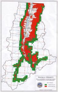
By declining to adopt any new map defining the Wildland Urban Interface (WUI) in Ravalli County, the County Commissioners virtually ensured last week that the state will continue to use the existing map adopted in 2007 and included as part of the Community Wildfire Protection Plan (CWPP).
The commissioners reviewed the 2007 map as well as two additional alternative maps before deciding to take no action on the issue. As a result, the state Department of Natural Resources and Conservation will, by default, use the last map officially adopted by the county when making decisions related to the WUI. Those decisions primarily concern and help facilitate the implementation of two federally funded grant programs for fuel reduction projects on private property. The landowner pays a portion of the costs and properties within a designated WUI have an increased chance of obtaining the grants.
The Bitter Root Resource Conservation and Development Area, Inc. received a grant from the USDA Forest Service – State & Private Forestry, to facilitate the development of a Community Wildfire Protection Plan, or “Community Fire Plan” almost a decade ago.
Diverse groups of valley residents met repeatedly during the winter of 2002-2003 to brainstorm and prioritize potential actions to address the most pressing issues that affect the Valley’s ability to reduce the risks associated with wildland fires. The work was a cooperative effort between volunteer fire chiefs, county officials, conservationists, community-based non-profit organizations, real estate agents, tourism and timber industry leaders, federal and state land managers, business people and interested residents.
The plan was founded on, and will guide the implementation of the National Fire Plan and the related 10 Year Comprehensive Strategy and Implementation Plan in the Bitterroot Valley.
The plan was intended to be an adaptive document, as it states, “one that will continue to be updated annually or as needed, to reflect our accomplishments and the newly emerging needs, issues, and opportunities surrounding wildland fire management in Ravalli County.”
As part of that updating process, in 2010, the Bitter Root Resource Conservation & Development (RC&D), Bitterroot National Forest, Montana DNRC, the Wildland Urban Interface Task Force, and All Valley Fire Council came together and with boots on the ground and detailed aerial photos conducted an intensive re-assessment of the WUI in terms of the concept of “contiguous fuels.” Rather than looking simply at forested lands abutting the national forest, they looked at all lands contiguous to the national forest that were covered with any sort of burnable fuel, including grasslands. A map outlining these lands was produced in 2010.
Ravalli County Planning Department Manager Terry Nelson also produced a map showing only those properties with boundaries immediately adjacent to the National Forest boundary.
Commissioner Matt Kanenwisher then presented a slide show presentation consisting of excerpts from a Headwaters document, a Montana Fire Chief’s Association position paper from 2008, the Healthy Forest Restoration Act of 2003, and quotes form DNRC Director Mary Sexton, which he said all indicated that once the county adopts a map designating a WUI that the state will then begin adopting rules to govern building in the designated area, including possibly new building codes planned by the Labor Department, all of which will amount to a sort of de facto zoning in Ravalli County. He said insurance companies will no doubt use the designation to raise insurance premiums on those properties in the designated zone.
“The WUI does nothing but provide a framework for further regulations,” said Kanenwisher.
Commission Chairman J.R. Iman expressed his agreement.
Commissioner Greg Chilcott said that it was a good place to start a discussion and that the information presented by Kanenwisher “elevates the suspicion level.”
Commissioner Ron Stoltz said that he had quite a few conversations with “the fire community” and had asked them to being him the grants that have been awarded for fuel reduction in the WUI and that none were submitted to him.
“I believe this is an attack on private property rights,” said Stoltz.
Commissioner Suzy Foss agreed, saying that “anything beyond properties immediately adjacent to the national forest is an intrusion on private property.”
Mike Kopitzke, DNRC Fire Program Manager for the Southwest Land Office, explained that from his agency’s perspective the national forest land was, generally, not considered as part of the WUI because the DNRC’s operating definition was land with structures intermingled with burnable fuels.
“Our mission is firefighter safety, human safety and the protection of structures,” he said. “It’s the protection of lives and property.”
Kopitzke noted that local firefighters had come up with an updated map. He said, “DNRC has no interest in designating a WUI in Ravalli County. We would like you to do it.” He said if the county did not adopt a new WUI map that his agency would use the last map officially adopted by the county in the 2007 CWPP.
There was some discussion about the 2010 map in which all contiguous burnable fuels was used as the criteria and the commissioners expressed concern about the inclusion of pasture land in the equation.
Paul Moore, Unit Manager for DNRC in Ravalli County, noted that more firefighter fatalities occur in grassland fires than in forests. He noted also that $870,000 in fuel reduction grants had been awarded in Ravalli County in the last five years covering close to 4,000 acres.
Commissioner Kanenwisher noted that this was such a small portion of the at risk area that it was hardly significant.
Commissioner Chilcott suggested that the commission confirm the 2007 map and take no further action.
Commissioner Kanenwisher said there was no reason to confirm the 2007 map.
“We have that by default and that’s the situation,” he said.
The commission took no action.
Ed White says
I don’t think my comment would be appropriate.