by Michael Howell
“Whiskey is for drinking; water is for fighting.”
Insightful claims are often attributed to some indubitable source to bolster their credibility. This quote is most often attributed to Mark Twain, but multiple researchers have examined this saying and found there is no substantive evidence that he ever said or wrote it. But that it is a witty expression of the importance of two significant factors involved in the settling of the American West can hardly be denied.
Saloons were a hallmark of every boom town in the state and a major trade item with the native tribes. It’s also true that the origin of Montana water law began with a shootout between two irrigators right here in the Bitterroot Valley. Although it began with disputes over surface water rights, it is also true that the battleground over water has deepened as underground aquifers across the West are being depleted due to overuse and drought.

Here in our state, the Montana Bureau of Mines and Geology (MBMG) was established at Montana Tech as a non-regulatory agency to provide unbiased, scientifically based data to enable the sound use of our geological and water resources. As part of that effort, a team of hydrogeologists from the Montana Ground Water Assessment Program, a division of MBMG led by Professor Ginette Abdo, recently gave a presentation on groundwater in the Bitterroot Valley to the Ravalli County Commissioners.
Abdo, the agency’s Ground Water Investigation Program Manager, told the commissioners that her agency began a groundwater characterization study in Missoula and Ravalli Counties as early as 2000 and that research continues to this day. She said the work is being driven by questions about the impacts of residential development and the accompanying removal of lands from agricultural use, the change from flood irrigation to the use of sprinklers, and other such concerns.
According to Abdo, the Ground Water Investigation Program is a stakeholder driven program that responds to requests from local stakeholder groups seeking answers to particular issues in their area. In the Bitterroot Valley they have done studies on Lolo Creek, the Eight Mile and Three Mile drainages, the Stevensville to Corvallis area along the Bitterroot River, and in Hamilton.
In Lolo, the agency evaluated the causes of intermittent dewatering in lower Lolo Creek where they discovered that pumping water for domestic use caused minimal changes to surface water flows in the numerical model as compared to direct diversions from the creek.
In the Eight Mile and Three Mile Creek drainages, they collected data to evaluate the effects of residential development on groundwater and surface water from 2010 through 2011 but due to a funding shortfall have not yet analyzed that data. Commissioner Jeff Burrows asked if the county needed to re-submit a request to get that study completed.
“We need to do that,” said Abdo. “It doesn’t need another request. It’s on our docket but it will take at least a year or a year and a half to get those results.”
The study done along the river between Stevensville and Corvallis was to evaluate the possibility of using groundwater to supplement or replace surface-water irrigation. The results indicated that groundwater was a viable option for irrigation. Converting from flood to pivot sprinkling would reduce irrigation return flows to Mitchell Slough and the Bitterroot River and would reduce flows out of Mitchell Slough.
In the Hamilton area they evaluated potential changes in groundwater elevation and nitrate concentrations in response to increased population.
According to Assistant Professor Sara Edinberg, the number of water wells in the Bitterroot Valley has increased from 3,100 wells in 1970 to 25,375 wells in 2023.
The amount of groundwater use for different purposes is also changing.
GROUNDWATER USE
Purpose of use amount in millions of gallons per day
Year 2000 Year 2015
Domestic 2.14 2.48
Irrigation 4.81 2.57
Public water supply 2.00 2.98
Stockwater 0.13 0.13
Industrial/commercial 0.12 0.21
According to Edinberg, far more surface water gets used for irrigation than groundwater. The combined use of surface and groundwater totals about 389 million gallons per day.
Water quality in wells in the county is pretty good with nitrate concentrations almost all running under the 10 mg/L threshold for safe drinking. Total Dissolved Solids are also mostly all under the recommended threshold of 500 mg/L. There is a cluster of wells in the foothills of the Willow Creek drainage, however, with high levels of naturally occurring arsenic.
The program is monitoring 900 wells for long term water levels across the state and 38 are located in Ravalli County.
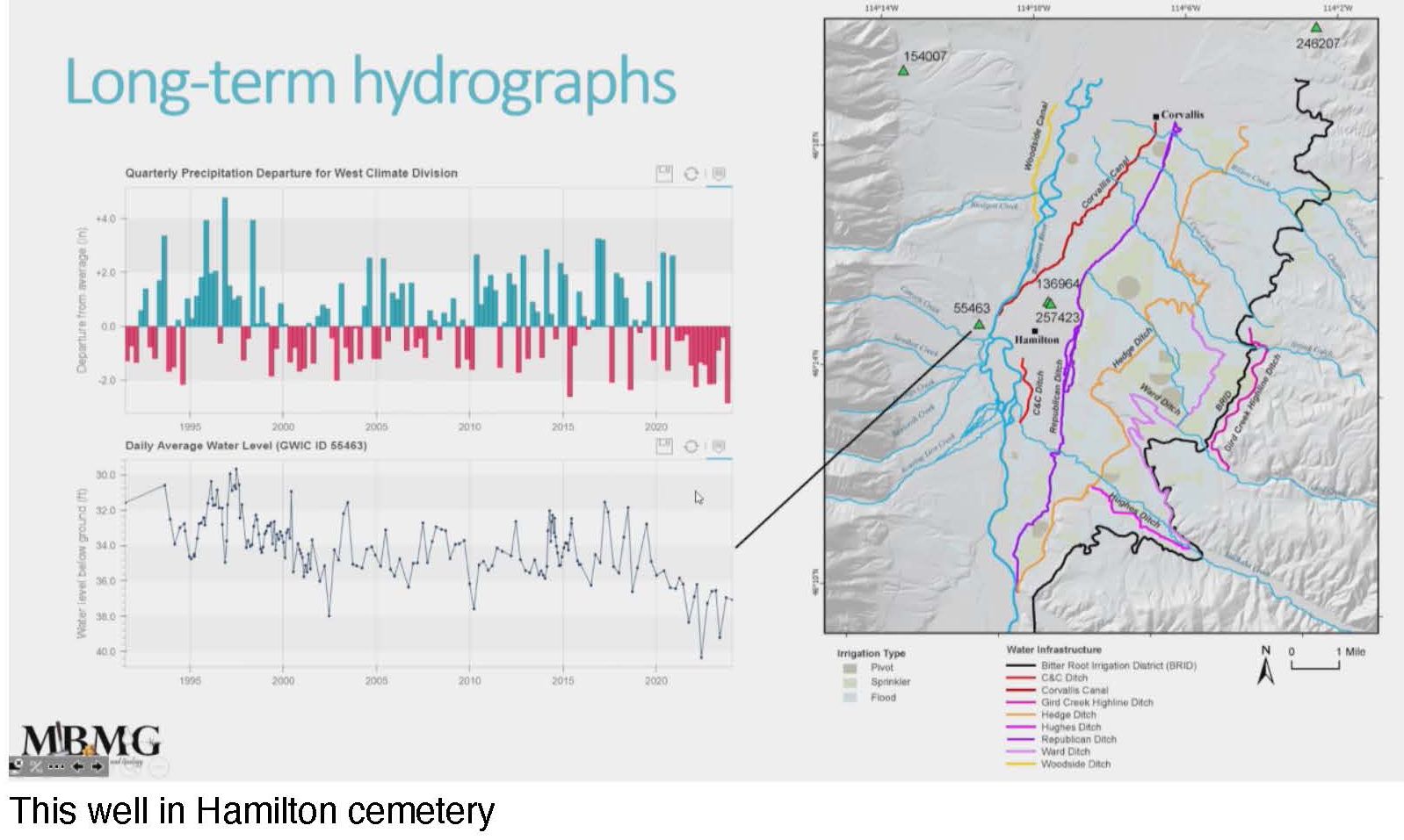
Long-term hydrographs showing above average (blue) and below average (red) precipitation in the valley clearly display the three-year drought conditions over the last three years, 2020-2023. The lower graph shows how some well water level trends, like the ones at the Hamilton Cemetery displayed here, generally follow the precipitation trends.
The bottom graph shows how water levels in a well at the Hamilton Cemetery generally follow the precipitation trends.
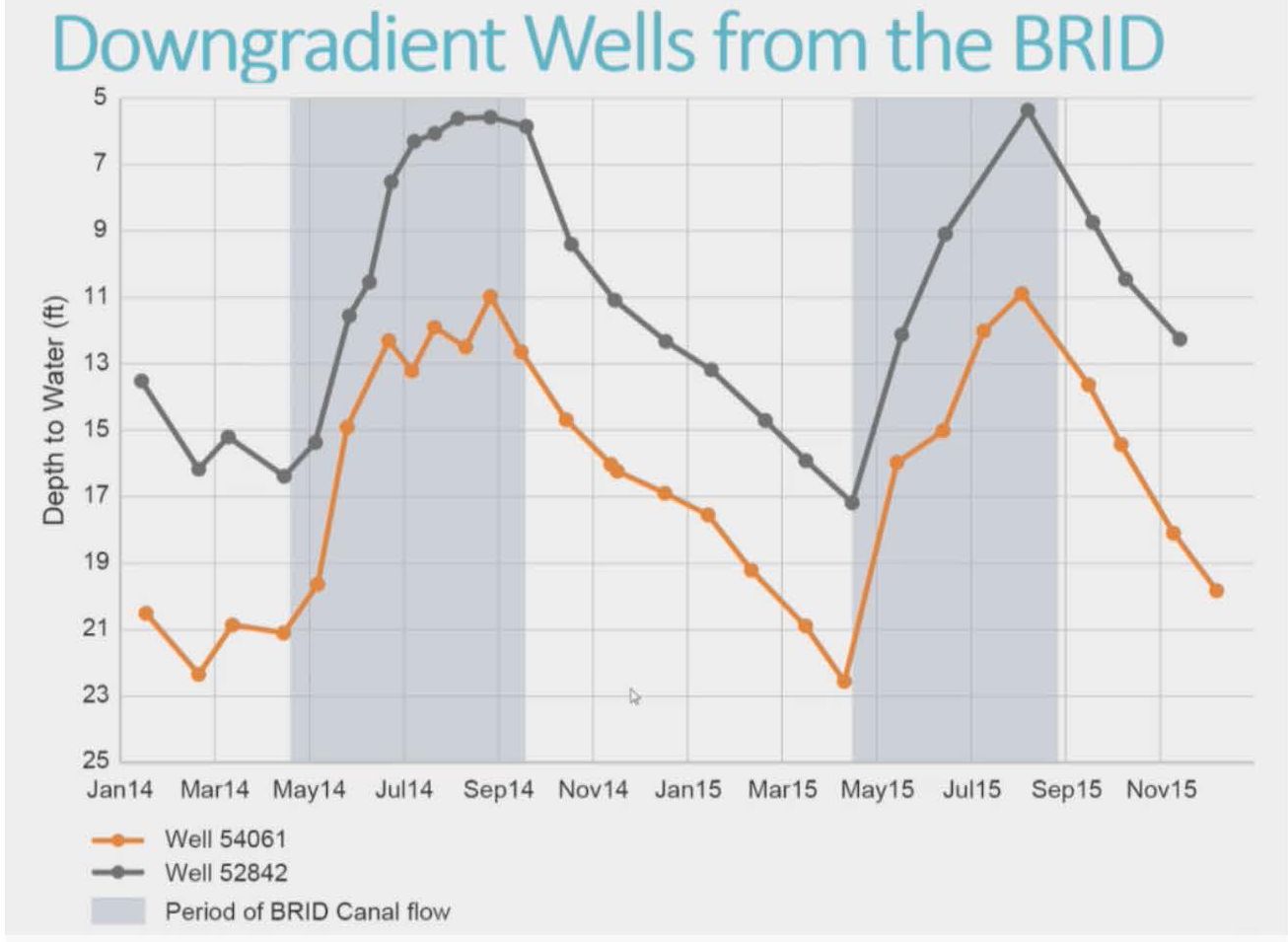
Although water wells do generally follow precipitation trends one thing that can significantly alter the water levels in a well is leakage from a nearby irrigation canal. This is clearly demonstrated in the graph of water levels in wells located downgradient from the Bitter Root Irrigation District (BRID) ditch. The grey areas in the graph in which water levels spike are periods in which the BRID Canal is flowing.
The data indicates that the BRID Canal in a 5.8 mile stretch near Hamilton loses 1.3 to 3.4 cubic feet per second (cfs) of water per mile depending on the time of year due to leakage into the groundwater.
Research hydrologist Todd Myse explained how a Bitterroot River water budget was calculated on a 9.8 mile stretch of the river extending from Anglers Roost to Woodside Crossing for a few months in 2014 and all year in 2015. It turns out that the Bitterroot River is gaining groundwater in every month throughout the reach.
It was determined that about 35% of the recharge to the aquifer in the area was coming from flood irrigation flowing off the fields and not being used by the plants (15%), from BRID leakage (11%), and from other canals (7%). About 15% of the recharge was coming from the streams entering the river on that stretch and 1% was coming in the form of precipitation. The remaining 51% of recharge was from other groundwater passing through.
About 90% of the outflow from the aquifer was passing on as groundwater; 4% was exiting as surface water; 3% was escaping through riparian evapotranspiration, and another 3% through domestic use.
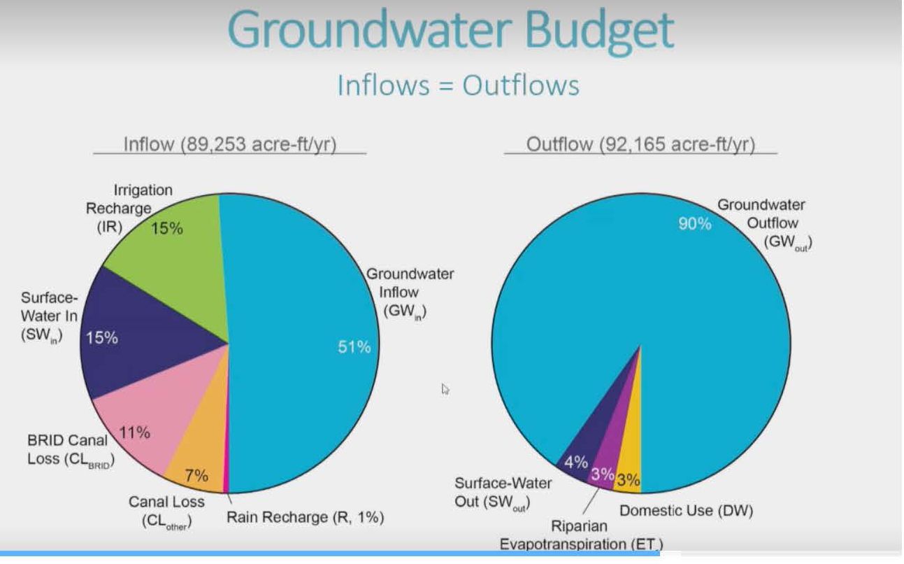 In summary Myse noted that a lot of the recharge to the aquifer, around 35%, related to agricultural practices so changes in land use such as removing land from agriculture or simply changing irrigation practices from flood to sprinkler or lining a ditch affects the recharge in the area. Since the Bitterroot River is gaining groundwater as it goes along, he said, any of these changes can change the inflows into the Bitterroot River.
Myse said some recommendations based on this information would be to continue groundwater and surface water monitoring to evaluate future trends, check wells in high population growth areas specifically, and look for and identify bedrock and fine-grained sediment aquifers that have low permeability and lower recharge rates. He said that even though nitrates don’t seem to be a problem, it is a good idea to monitor that to see if anything changes.
It is important to remember, he said, since the aquifer here is connected to the Bitterroot River, any sort of changes in land practices that affect the aquifer can also affect the Bitterroot River.
Myse said the state was already giving a lot of attention to the possibility of Managed Aquifer Recharge. He said that, since the snowpack is starting to be released earlier and over a shorter time period, they are looking for ways to slow down the run-off, keeping it in the aquifer for slow release later in the season. He said the state was using a GIS system now to try and find good areas in the state to try such practices.
Commissioner Burrows asked if that kind of project would work anywhere here. Myse said he didn’t know. He said a study would have to be done to find that out.
Commissioner Dan Huls said he would like to see such a study done here.
Myse said, “Put it into a proposal. We would love to come back.”
Jeri Drake says
Helpful but confusing. This entire article needs to be in the Rav. Rep.