by Michael Howell
On September 8, and again on September 15, the County Commissioners’ meeting room was packed with people wanting to have their say about the Calf Creek Subdivision proposal, a four-lot subdivision proposed in the Hamilton Heights area northeast of Hamilton. Everyone who spoke expressed opposition to the proposal, primarily about the potential negative impacts on neighboring agricultural operations and neighboring wells and wildlife. The only ones speaking in favor of the proposal were representatives of the engineering company WGM Group. Being a minor subdivision, that is a subdivision into 5 or less lots, the proposal did not receive any review by the Ravalli County Planning Board but went straight to the County Commissioners for a decision. The property is owned by Robert Gene Foley and Christine Gayle Foley, Trustees of the R and K Foley Living Trust, James Martin Foley and Theresa L. Furrow, Trustees of the Foley Living Trust, and Stephen R. Foley, but is being developed by Gary Chilcott and John Giuliani who also own land in the area. Commissioner Greg Chilcott recused himself from the process as he is the brother of one of the developers. So the final decision will be made by Commissioners Dan Huls and Jeff Burrows.
The proposal involves splitting 84.3 acres of farmland into four irregularly shaped lots, each a little over 20 acres in size. County Planning Director Rob Livesay kicked off the discussion with a little background on the development, saying, “I think the history of it is important here because I don’t think there is anyone here today who doesn’t remember the Sapphire Heights Subdivision.” That proposal stretched across 120 acres including the Foley property and would have created 12 lots, ten of which were on the roughly 80 acre parcel now under consideration. The Sapphire Heights Subdivision proposal was withdrawn when the Planning Board found that the potential negative impacts on wildlife, specifically related to FWP comments about the impacts of such a large reduction of elk winter range, could not be mitigated. It was revised and re-submitted as the Calf Creek Subdivision.
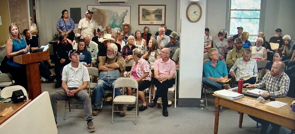
Jamie Erbacher of WGM Group Inc. (left) presents details about the Calf Creek Subdivision to the Ravalli County Commissioners in a room packed with people in opposition to the proposal.
Livesay gave a staff report assessing the proposal in terms of the state criteria, noting first off that state law prohibits the county from considering whether the subdivision will result in the loss of any agriculturally significant soils when reviewing the impacts of subdivision on agriculture. In terms of impacts on water users, he noted that the developer elected to sever all water rights on the property, limiting water use to four exempt wells, and to place easements on the ditches which traverse the property. They also proposed a 100 foot wide no build zone and 150 foot no fencing zone, establishing a green belt and wildlife corridor through the property. To mitigate impacts on local services they offered $1,500 per lot to the fire district; $500 per lot to the school district; $740 per lot to the Sheriff’s Department; an enlarged access area to mitigate impacts on emergency services; and an $80,000 pro-rata fee to the grader district to mitigate adding 38 vehicular trips per day to the county road.
Surface water features on the property include Calf Creek, an unnamed drainage and associated wetlands, and Willow Creek Low Ditch with two laterals. Nearby water features include Willow Creek, Stuart Creek and the Bitterroot Irrigation Canal. They proposed mitigating the negative impacts by limiting the use of the proposed exempt wells to 4 gallons per minute pumping capacity and 600 gallons per day use and requiring 2,000 gallon cisterns for each property for irrigation purposes.
Analysis of four wells upgradient from the subdivision found levels higher than maximum contaminant limits deemed acceptable for drinking by DEQ for arsenic, nitrates, flourides, sodium and bacteria. As mitigation, the developer said covenants would require individual filtration devices on the wells.
As to impacts on groundwater and neighboring wells, it was stated that the wells were likely to produce 2.5 to 4.7 gallons per minute with a radius of influence likely between 114 to 204 feet per well at the 600 gallons per day limit. As mitigation they offered a 300 foot set back from the property lines and a cistern.
In terms of water availability, the planning staff recommended an independent water availability report addressing availability of the underlying aquifer to meet proposed domestic and irrigation water use for each lot, taking into consideration the subdivision record as a whole including application materials, comments and credible evidence collected as part of the governing body preliminary review, with the result being a recommendation on water availability done by an independent qualified professional and done according to county policy and paid for by the applicant.
The Planning staff recommended approval of the subdivision conditioned upon associated mitigation requirements.
Public comment was extensive and passionately in opposition to the proposal. Neighboring landowners contested the reports by WGM. They claimed that WGM was using outdated well data that did not adequately characterize the existing conditions and dismissing data as “not reported” when it actually meant that the well was dry. Several people testified to having wells with very limited yields that run dry and require hours, even days, to recharge.
Bill and Faith Kemp, who live on a parcel adjacent to the proposed development, said they were not told about the water problems when they bought their place 23 years ago and had to wait 10 minutes for the well to recharge when they moved in. This past winter, she said, there was no recovery, and they had to install a cistern. They also discovered that they had arsenic and nitrate contamination in the water.
“What about the ethics of this?” Kemp asked the commissioners.
Felice Fausto, another adjacent property owner, said that two of the three wells on her property were running dry.
There was testimony and evidence presented by others that the proposed green belt and wildlife corridor were woefully inadequate to mitigate the concerns over the reduction in elk winter range.
Andy and Alan Maki, neighboring irrigators with historic water rights that pass through the property, testified that severing the water rights on the property would negatively impact the water users downstream. In response, the developer agreed to leave the water rights with the land and allocate it proportionally to the four lots. This option, however, also met stiff objections from the irrigators due to the complex number of water rights involved. Alan Maki called any change in the use of the water rights “unmitigable.”
The Planning Director noted later that if the water rights were not severed, the developer would need to present an irrigation plan as a condition of approval.
John Heiland, named after his grandfather John Foley, agreed with the Makis, saying, “I agree that landowners should have rights over their property, but those rights shouldn’t extend to taking away water that my family has depended upon for generations. One person’s freedom to subdivide should not come at the expense of their neighbor’s ability to make a living.” He said the commissioners should make sure that the water for a new subdivision is “based on actual availability and not just on paper promises… Please make sure that decisions you make today do not destroy agriculture tomorrow.”
Tina Donnelly, an engineering specialist for 40 years, presented documentation from the Montana Groundwater Assessment of 2011 and an update by the Montana Bureau of Mines and Geology concerning the extent of the natural arsenic and nitrate contamination in the area and its potential for impacting human health and causing biological damage in the environment. She argued that, by breaking up the bedrock by drilling and construction work, the arsenic and nitrate would be mobilized, impacting downgradient wells through the groundwater and producing airborne contamination as well. She said that mitigating the arsenic problem by requiring the new property purchasers to install filtering systems did not mitigate the impacts on downgradient property owners.
Andrew Gorder, legal and policy director for the Clark Fork Coalition, said his organization owns 13 water rights in the Bitterroot Basin to restore water flows in the basin and has been fighting exempt wells writ large since 1993. The Bitterroot River basin has been statutorily closed to any new surface water rights since 1999 due to significant over-appropriation of water.
“You cannot get a new water right in the system without developing a plan for mitigation of a new depletion,” said Gorder. “You can only get a permit for groundwater in a closed basin if you conduct a hydrogeological report and potentially develop an aquifer recharge or mitigation plan.” He said the Calf Creek development also lies within the Willow Creek basin closure in effect since 1994. Under this administrative closure, the DNRC cannot grant any new permits for surface or ground water that would result in the consumption of any amount of water between May 1 and September 30.
“Why do we have these statutory and administrative closures?” he asked.
He said the Calf Creek project proposes to drill four new exempt wells totally outside the DNRC’s permitting process, which means no individual notice to neighboring water users, no opportunity for those water users to formally object to defend their water rights, no agency analysis to determine if there is water either legally or physically available, and zero analysis as to whether the new water use will affect any existing water users. He said the developers have tacitly admitted that there may be negative effects on neighboring water users and have proposed mitigation measures such as covenants to restrict new wells to using no more than 4 gallons per minute pumping rate and no more than 600 gallons per day per household.
“The question is, is that good enough?” said Gorder. “I don’t know and unfortunately no one is going to take a hard look.”
He said the staff report states that the developer will provide an independent water availability report by a licensed hydrogeologist demonstrating that there is an adequate water source available for each lot, “but even if we assume that this is true, that does not address the question of whether or not that withdrawal will negatively affect neighboring wells, ditches or the underlying aquifer itself… I would urge the commissioners to listen to the testimony you have heard today and assign it the appropriate weight in this process.” He said that a recent case in District Court (the Broadwater County case) has established that the Commissioners have a legal obligation to examine the physical and legal availability of water for the proposed subdivision.
“It goes against all logic that you would have these mechanisms in place designed to head off negative impacts to existing wells, water rights and water resources and yet we continue to authorize more and more exempt wells to be drilled into the aquifer and simply pretend that this growing number of straws is not going to have an impact,” said Gorder. “I think it is simply not true, so for all these reasons we ask that you deny approval of this project.”
At the September 15 meeting, Mike Day of WGM Group told the Commissioners that there is legal case history establishing that no landowner can be required to exercise their water rights in order to recharge someone else’s well. But, he said, in response to public concern, in response to the objections about severing water rights, the developer would agree to allocating the water rights to each lot. Julie Merritt of WGM Group said that the amount of carriage water dedicated to downstream water users would need to be calculated.
James Rummel told the Commissioners that he was concerned about the loss of agricultural rights not just in this case but across the whole county. “But I don’t know how to fix that,” he added.
“I do,” said Commissioner Burrows, “talk to your legislators. We cannot consider the impacts on loss of agricultural soils in making our decision. Our hands are tied, and we can’t ask for mitigation of the loss of these soils to agriculture.”
Commissioner Huls said, “I support the right to farm and ranch, but I can’t be sentenced to it.”
Andy Maki said that in 1950, 70% of Montanans’ food was produced in Montana. Today, he said, it’s 3%, “and this trend should concern us.”
“I realize we have the seven criteria in state law, but there is a clause in the Montana Constitution, and we do have a duty in Montana to protect, promote and enhance agriculture,” said Maki. “We keep trying to put square pegs into round holes but it’s not working. We are reaching a threshold, a tipping point and it does affect agriculture. You need a certain degree of scale to keep agriculture here. We are chasing our young people away.”
Alan Maki said there are nonmitagable impacts on agriculture. “Cenex is thinking of leaving the valley and going to a valley with less development. If you think that is not an effect of taking farmland out of production, you are kidding yourself. It’s not about the soils, it’s about Cenex leaving.”
Albert Babel said the U.S. is losing 2,000 acres of farmland a day, that’s ¾ of a million acres a year. He said we have about 280-290 million acres of tillable farmland, and it won’t last long at that rate. He said food production was what made a country strong and having to depend on others for food was a weakness. “We have to decide whether we are going to be a strong country or a weak one,” said Babel. “As a county we have to decide if we are going to be weak or if we are going to be strong and stand up to urban sprawl.”
Burrows said in terms of taking land out of agriculture, the public needs to look back to Legacy Ranch. “We were going to protect that entire area by denying a subdivision,” he said. “Have you seen it lately? To deny a subdivision is not an answer to the problem. The legislature has continued to loosen the constraints on family transfers so now you can do unplatted subdivisions. Right, wrong or indifferent, that’s what they did. Subdivision for rent or lease regulations have been relaxed more. There are options to develop this property without subdividing. There could easily be five lots out there without public review. Denying a subdivision will not save that property from development. You could put storage units in, put up a cell tower. No mitigation, no covenants controlling anything.”
Pamela Van Sant noted that there is nothing in current the proposal stopping them from further dividing the newly created lots.
In response the developer agreed to placing a restriction limiting any further subdivision.
A motion was approved that proposed mitigation for impacts on agriculture were sufficient.
The Commissioners then moved on to consider the second state criteria of potential impacts to water users and water user facilities, and the proposed mitigation of severing the existing water rights to the property.
Commissioner Huls said it would be very detrimental to other water users downstream.
The alternative was to allocate the water rights proportionally to the lots. County Planning Director Livesay said if that was done there would need to be a Master Irrigation Plan.
Carolyn Generick noted that the State of Montana owns the water rights and only the state could determine whether anything is severed or not. Severance of the rights would require DNRC review and approval.
Burrows said, “I don’t know which is best, severance or allocation. Both are problematic. We need to know how much water rights are below. We can’t make this decision till we know the answer to that question.”
Jerry Downey, who has lived at the confluence of Calf Creek and Willow Creek since 1972, said that about 25 years ago Calf Creek began to stop flowing into Willow Creek in winter months.
“It’s a finite resource,” he said, “now four more straws in the glass. How will this affect flows in Calf Creek? You have heard talk about tipping points. I think in some ways it has already happened.”
Burrows asked Huls, “Is it better to severe or allocate?”
Huls replied, “That’s one of those 50/50 deals.” He suggested they move forward with the idea of severing the rights since that is what was in the current application.
“I guess I don’t have enough information to decide about severance or allocation,” said Burrows.
Burrows suggested they could add a Findings of Fact that the developer has agreed to allocate the water rights proportionally among lots. Better yet, he said, they could add a requirement that some water be allocated as “carriage water” to ensure that downstream water users got what they had a right to.
Mike Day of WGM said that if water was apportioned to the lots a certain amount could be dedicated as “carriage water” and the remaining could be severed.
Maki raised the question of which water rights were under consideration and who would be responsible for upkeep of Gleason Lake which held all the late season low flow water.
This devolved into an extended discussion of all the water rights involved and how the lake played into it.
Day of WGM said, “We would have to make a plan to determine proper apportion and which water right is being used.”
Commissioner Huls said, “We could keep slugging away, but I think we can’t continue until we get the information we need.”
The developer granted an extension of the September 29 deadline for a decision and another meeting was scheduled for September 30 at 9:30 a.m.
Tracy says
Sounds like a GREAT subdivision getting the “Highest and Best” use of the land involved. Ag has NEVER been the best use of land in the Root. HOWEVER, Pouring precious water on dirt to grow a marginal crop is a waste but then so is pouring it on grass to keep it green. That water should be only for consumption. Leave in it the ground so it gets to the river for the fishes. Look at the waste in every town. The folks at McDonalds in Hamilton water the boulevard on second street so heavily that there is standing water on second street all summer long. Just a huge waste of water.