| Acres: 587 acres
Start Date: July 17th, 2022 Cause: Lightning Origin Location: 18 miles East of Hamilton Facebook: Hog Trough Fire Information Fire Information: 406-763-1134 daily from 8am-8pm |
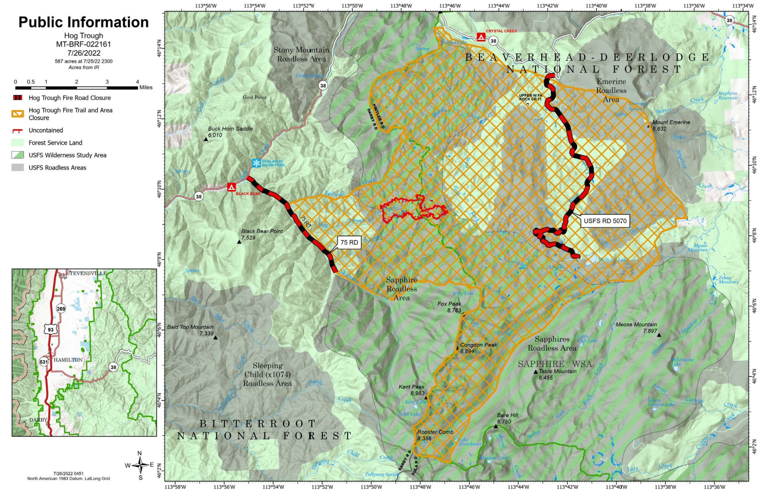 Percent Contained: 9% Percent Contained: 9%
Jurisdiction: Bitterroot National Forest and Beaverhead-Deerlodge National Forest Website: https://inciweb.nwcg.gov/incident/8258/ Total Personnel: 124 Resources Assigned: 3 Hand Crews, 5 Helicopters, 4 Engines, 1 Skid Engine A Temporary Flight Restriction (TFR) is in place over the fire area. Please do not fly drones near wildfires. Unauthorized drones were spotted near the fire over the weekend. Use of unauthorized unmanned aerial systems (UAS), or drones, in a fire area endangers the lives of pilots and firefighters. Know before you fly. Skalkaho Highway (Highway 38) is OPEN. To ensure firefighter and public safety, Forest Service 75 (Skalkaho-Rye) Road is currently closed from the junction of Highway 38 (Skalkaho Highway) to Mile Marker 5 near Skalkaho Creek-Jerry Lake Trailhead #503. Forest Service 5070 (Sand Basin Creek) and 5071 Road is currently closed. Summary: The Hog Trough Fire is at 587 acres and is burning in the Sapphire Wilderness Study Area (WSA) on both the Bitterroot and Beaverhead-Deerlodge National Forests. No structures are currently threatened and no evacuations are in place. Planned Actions: Today, helicopters will provide water bucket drops over the fire to slow fire spread from impacting FS 5070 and FS 75 Road. Heavy equipment (feller bunchers and excavators) will continue work along FS 75 Road and FS 5071 by removing vegetation to prepare these roads as potential containment lines. Crews are nearing completion of fuel reduction work on FS 5071 Road. Hand crews will be preparing Skalkaho Creek-Jerry Lake Trail #503 and scouting other potential containment lines. Fire manager’s objective is to keep the fire south of Highway 38, east of FS 75 Road, and west of FS 5071 Road. Fire Activity: Fire activity will increase around 2:00 PM today with single andgroup tree torching and short-range spotting. The southwest and northwest corners of the fire are beginning to show more active fire behavior. Due to significant safety threats and inaccessibility, firefighters currently are not directly engaging the fire on the ground. The area near the fire contains heavy accumulations of woody debris and thickets of regeneration with trees being 6-15 feet tall. Fire Danger: Fire Danger is at Very High on the Bitterroot National Forest. Fire Danger is High on the Beaverhead-Deerlodge National Forest. No fire restrictions are currently in place. For current fire restrictions, visit mtfireinfo.org. Closures: See Inciweb for specific closure information.
|