For the first time on the Bitterroot National Forest a drone is being used to map and provide live surveillance of the Cinnabar Fire in the Welcome Creek Wilderness northeast of Stevensville.
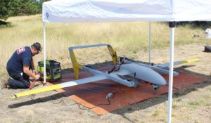
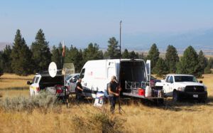
An Unmanned Aircraft Systems (UAS) team from Bozeman-based Bridger Aerospace (BA) arrived on Friday and set up a mobile ground station in the 3-mile area from which to launch and land a surveillance drone. The drone is also piloted from a mobile command center parked near the launching and landing pad, which looks like a large rubber mat laid out upon the grass.
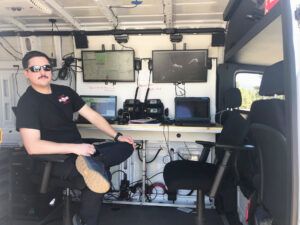
Portable antennas and small satellite dishes are pulled out of the van and assembled. The whole unit is self-powered and four large computer screens are mounted on the wall of the van with room for a pilot and a co-pilot at the controls.

This UAS is not one of those little drones used commonly by realtors, hunters and most other private citizens. This is a real aircraft, in comparison, in fact the plane is registered with the Federal Aviation Administration as a fixed-wing aircraft. It is a hybrid fixed-wing/Quadrotor plane with a wingspan of over 15 feet and, while the commonly marketed little quadrotor UASs can stay aloft for about 20 minutes, this plane can fly up to 12 hours with a payload of about 20 pounds and almost 24 hours without a load.
The payload on this fire reconnaissance mission consists of two camera systems. One system in the shape of a small globe is mounted under the front nose of the plane. The other is mounted in the belly of the plane. Both systems have both daylight and infrared capability.
According to BA team manager Weston Irr, the cameras in the belly are used for general surveillance. It can take still pictures on demand or they can fly a straight line and later stitch the still pictures together and make a ‘strip map’ of the flight path. Or they can fly over a large area taking pictures and stitch them all together into an ‘orthomosaic’ map and create a map of the whole area.
The cameras on the front are mobile and can be pointed in any direction and are manually controlled by the pilot back at the ground station.
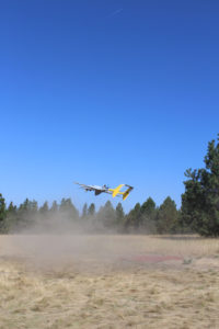
When permission to launch into a temporarily restricted air space was finally granted by the FAA, the UAS was launched Saturday morning. The plane can climb to about 18,000 feet. But the ceiling on the temporary flight restricted area was 12,000 feet, so the drone leveled itself out at 11,000 to 11,500 feet altitude to a series of parallel flight paths over the area.
Back at the ground station we could see the tracking van and surrounding vehicles and the launch site from several thousand feet in the air.

Dan Osterkamp, data specialist for the Bureau of Land Management, an agency cooperating in the fire surveillance effort, was excited about the prospect of using this real-time surveillance capability on forest fires. What the UAS sees through its cameras can be shared with teams of specialists in varying places over computers around the country and even with firefighters on the ground.

“We can share the images of selected areas with Hot Shot crews on the ground using their cell-phones,” said Osterkamp. By using the Zoom platform on the internet, the live flight visuals can be shared among any number of individuals.
According to Irr, the fire can probably be mapped in about two hours and after that the plane can visit any area of the fire upon request and help identify hot spots or provide closer visuals for making strategic decisions on the ground or in planning defense lines.
“With a plane like this on a fire the firefighters have a fresh, up to date map of the fire every morning before going out,” said Irr.
The drone may be seen in action over the fire in the coming week. Private drones, which are dangerous to operate in the vicinity of helicopters and planes, are restricted from flying in the area.
The lightning-caused Cinnabar Fire started on August 19th. Currently is 0% contained. 268 personnel are currently assigned to the fire which, as of Monday, August 31, was listed at 2144 acres.
Northern Rockies Team Seven, a Type II Incident Management Team, is currently managing the incident. Resources assigned to the incident include: two hotshot crews, three initial attack crews, two engines, one camp crew, seven helicopters and several pieces of heavy equipment.
Sunday’s fire activity resulted in an increase of a couple hundred acres. Most of the growth occurred in Ferret Creek as the fire burned to the northeast towards Welcome Sawmill Saddle and the 2007 Sawmill Fire scar. On the western edge, the fire has neared Bitterroot/Rock Creek Divide Trail #313 in some areas. Helicopters worked hot spots with bucket drops throughout the fire. The Unmanned Aircraft System (UAS) collected additional data for fire staff to use in managing the fire.
Line construction and improvement operations are ongoing. Masticators and heavy equipment are working along the 4268 road. Crews on the western edge will monitor and hold the fire at Bitterroot/Rock Creek Divide Trail #313. Fire activity will likely be minimal with the incoming weather, but will continue to creep and smolder.
Cooler weather arrived on Monday with temperatures in the 60’s over the fire area and a 50% chance of wetting rain. After Monday, warm and dry weather was expected to return.
An emergency closure is in place for National Forest System lands on the Missoula Ranger District, Lolo National Forest, and Stevensville Ranger District, Bitterroot National Forest. The closure includes the entire Welcome Creek Wilderness and additional roads and trails adjacent to the Wilderness for public and firefighter safety. For the current closure and map visit Inciweb. The Rock Creek Road #102 corridor and recreation access remains open.
Fire Information Line: 406-356-6235
Fire Email: 2020.cinnabar@firenet.gov
Inciweb: https://inciweb.nwcg.gov/incident/7063/
Facebook: Lolo National Forest
Twitter: @LoloNF