• Skip to primary navigation
  • Skip to main content
  • Skip to primary sidebar
  • Skip to footer

Bitterroot Star

Bitterroot Valley's best source for local news!

  • Home
  • News
  • Sports
  • Opinion
  • Classifieds
    • Buildings
    • Farm & Garden
    • For Rent
    • For Sale
    • Free
    • Help Wanted
    • Real Estate
    • Sales/Auctions
    • Services
  • Legal Notices
  • Obituaries
  • Calendar
  • Services
    • Letter to the Editor
    • Place Classified Ad
    • Submit a Press Release
    • Contact Us
    • About Us
  • Subscribe

Bitterroot area waters remain high

May 17, 2018 by Michael Howell

Bitterroot River at Victor Crossing last Saturday. Not good for floating! Michael Howell photo.

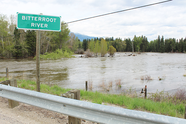
The flows in the Bitterroot River were trending steadily downward into Monday, reaching a low of 5.75 feet at the Darby Gage where Flood Stage is 7.5 feet. But after Monday, according to Luke Robertson at the National Weather Service in Missoula, the river was starting to inch up again and is expected to reach Flood Stage again on Friday afternoon.

The gage at Bell Crossing near Victor was also below Flood Stage on Monday, but is also headed upward and is expected to reach 11.03 feet, slightly over Flood Stage, on Friday afternoon.

The Bitterroot River at Missoula was slightly below flood stage on Monday but began rising again on Tuesday and is expected to rise to moderate Flood Stage of 12.14 feet by Friday evening.

On Monday, Robertson said some lowland flooding may occur around Darby and possibly some county roads but no homes were threatened in the area. He said the same holds true for the river between Lolo and Missoula where even more lowland flooding is expected along with potential flooding of county roads. There too, no homes are threatened.

On Monday, Montana Fish, Wildlife and Parks (FWP) closed the Clark Fork River to all recreation from Reserve Street Bridge in Missoula to Kona Bridge, due to dangers caused by downed power lines in the river and high-water levels full of hazardous debris.

The Incident Command for the Missoula 2018 Flood recommended the closure for public safety, after flood waters tipped power poles into the Clark Fork on Sunday. FWP says the closure will remain while power lines and other river debris are creating unsafe conditions.

The closure applies to all water-based recreation, including, but not limited to: wading, swimming, fishing, floating, boating. 

For more information visit the FWP website at fwp.mt.gov/news/restrictions/.

Share this:

Filed Under: News

Primary Sidebar

Search This Website

Search this website…

Local Info

  • Bitterroot Chamber of Commerce
  • Ravalli County
  • Ravalli County Economic Development Authority
  • City of Hamilton
  • Town of Stevensville
  • Town of Darby
  • Bitterroot Public Library
  • North Valley Public Library
  • Stevensville Community Foundation
  • Ravalli County Council on Aging
  • Bitterroot Producers Directory
  • Ravalli County Schools
  • Real Estate
  • Montana Works

Like us

Read our e-edition!

Montana Info

  • Montana Ski Report
  • Montana Fish, Wildlife, & Parks
  • National Parks in Montana
  • Montana Wildfires – INCIWEB
  • US Forest Service – Missoula
  • Firewise USA
  • Recreation.gov

Check Road Conditions

Road Conditions

Footer

Services

  • Place Classified Ad
  • Submit a Press Release
  • Letter to the Editor
  • Submit an Event
  • Subscribe
  • About Us
  • Contact Us

Our location:

PO Box 133

115 W. 3rd Street
Stevensville, MT  59870
Phone: (406) 777-3928
Fax: (406) 777-4265

Archives – May 2011 to Present

Archives Prior to May 2011

Click here for archives prior to May 2011.

The Bitterroot Star Newspaper Co: ISSN 1050-8724 (Print) ISSN 2994-0273 (Online)
Copyright © 2025 · Bitterroot Star · Maintenance · Site by Linda Lancaster at Bitterroot Web Designs